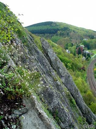
Rochers du Paradou
- Location: Yvoir (Yvoir)
- River: Haute Meuse
- Rock type: limestone
- routes:
- Equipement:
Important!
Most recent repetitions
- 17-02-24 - La Dalle Impériale L1 (6b) - haricot
- 01-10-23 - Voie à gauche de Another… (5c+) - Vieux lezard
- 01-10-23 - La Dalle Impériale L1 (6b) - Vieux lezard
- 16-09-23 - Portos (4b) - Renaat
- 15-08-23 - C'est Beau, C'est Bien (4b) - Vieux lezard
Topos, publications, sources
- Yvoir (Paradou), Topo (2007)
- Yvoir (Paradou) (1999)
- Guide d'escalade en Belgique Inventaire des massifs d'escalade(1991)
- Gids van de Belgische Rotsen 5. Beneden Maas(1979)
- Guide des rochers belges 5. Meuse en aval de Namur(1978)
- Guide des rochers belges 3. Haute Meuse(1977)
- Gids van de Belgische Rotsen 3. Hoogste Maas(1976)
Photos
All routes
Discover every route available on this crag by clicking on the link below.
Sectors
- La Dalle Rose
- Le Lierre
- La Grande Dalle
- L'Aiguille
- Dalles supèrieures
- L'école
- L'Arche (Grotte)
- Rocher du Tunnel
- Le jardin alpin
- Le Petit Lierre
- Les Couennes
Details
160 routes/pitches/variations
found in the Belclimb database
Sport climbing routes
Boulders
Aid climbing routes
Coordinates
NGI topographical map: 53/3-4Lambert coordinates: X 187.750 Y 114.250
UTM (ED50): 31U E N
WGS84: 4.8739°E 50.3372437°N


